 1
1Five days to go until America's total solar eclipse and there is a palpable excitement in the air. All the talk is now focused on the weather. Will we have to move? How good is the forecast? Is this the best forecast? What model is the best?
Before we begin, never lose sight of the fact that you are working in the virtual world of weather modeling and that the model is, at this stage, an estimate. Nevertheless, an estimate now can pay off in your planning.
Which Weather Model to Use and How to Use It
You can play with many models, but in the end, you will probably be no wiser and certainly no happier. They won’t all agree with each other, and they won’t make the same forecast the next time they run (every 6 to 12 hours). I don’t need that kind of grief, so I pick one model and follow it, trying to decipher a consistent message in its otherwise messy prognostications. That model is the NWS Global Forecast System (GFS) model, which is constructed to make long-range forecasts of the larger-scale systems. (It’s not tuned to handle thunderstorms, though it does make and move them.)
The College of DuPage's website provides a sample of models to choose from, all created by the National Weather Service. For the time being, we will use the GFS models (if you click through, click on the GFS tab), as the other models won’t come into play until Friday. You can select one of the four regions along the eclipse track, or simply look at the whole USA by just selecting a feature to display from the tabs on the left.
When it comes to long-range forecasting, I like to pay a lot of attention to the upper-level winds and the jet stream, largely because the models tend to be a little more reliable in the upper regions than down close to the surface, where mountains and other complex features influence the forecasts. In the past five days, I’ve been paying particular attention to the 250-millibar pressure level, which is the flow about 10 km above the surface. You will find it, labeled as “250mb” on the CoD model site, with a choice of either winds or humidity. I use the winds to evaluate the model’s stability and reliability. A slider along the top of the map display will allow you to go ahead to “18Z MON AUG 21 2017,” the approximate time of the eclipse.
Winds at the 250 mb level have been on a roller-coaster ride recently, but in the past two days, the GFS model seems to be getting a clearer view of eclipse day. Upper-level ridges and troughs – the ups and downs in the contour lines on the 250-mb map – have recently begun to repeat from one model run to the other. That’s a sign that the model thinks it has a handle on how the future weather will evolve.
You can have a look at how it’s been changing by following the tab “Compare to Previous Runs” on the bottom of the CoD map – just explore the various options that come up until you get the hang of it.
Weather Predictions for August 21, 2017
So, what do I see in the current (12:00 p.m. EDT, August 15th) model run?
The eclipse track can potentially be affected by two jet-stream flows. One, the polar jet, lies up around the Canadian border, and won’t have too much influence on the eclipse track if the model is correct. The other wind flow – the sub-tropical jet – arcs from southern California to Kansas and Nebraska and then heads eastward across Kentucky and out to the Atlantic.
Jet streams tend to carry a lot of upper-level cloud and they also give energy to both larger-scale weather systems and to thunderstorm development. We don’t have to guess about the impact of these two jets, as they’ve pretty much had the same pattern for the past two weeks: daily thunderstorms over the western mountains and the Great Plains.
To compound our problems, in the lower atmosphere, a persistent high-pressure cell has camped out in Texas, pushing moisture (fuel for thunderstorms) from the sub-tropical Pacific and the Gulf of Mexico northward toward the eclipse track. The whole situation is messy and it looks like it’s going to continue to be messy through eclipse day.
So, what is the model telling us for eclipse day? This figure shows the flow predicted for eclipse day, 144 hours in the future:
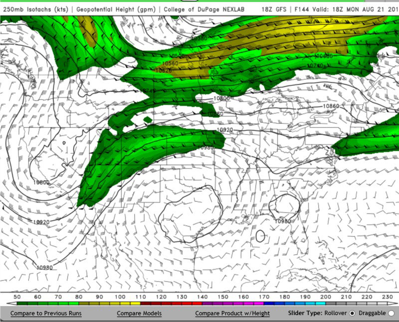
College of DuPage / NWS
In the northwest, the polar jet stream is mostly over Canada, but there is a trough extending southward into Idaho at eclipse time that’s causing me some concern. It’s trouble, because the region ahead of that trough will probably be pretty cloudy and may even have rain. In the past few forecasts, that trough has always been there, but it changes in strength and position: sometimes over Oregon, sometimes as far east as Wyoming. I’m going to be in Wyoming, and it looks like it might bite me.
The Great Plains part of the eclipse track lies under the sub-tropical ridge, which is normally good; but this is a pretty flat ridge and we’ve already seen that it’s responsible for the high moisture content across the plains. Though I don’t want to believe that the GFS has it all figured out, it fires up thunderstorms over Nebraska every night from the 19th to the 22nd. It’s worth thinking about, but don’t lose sight of the fact that these are virtual thunderstorms at this stage, not real ones. If the GFS and some other models yet to come online, are doing that on the 19th, we’ll have to deal with it.
From the Missouri River to the Appalachians, there is a modest ripple in the upper flow that will set off thunderstorms, but the ripple is too weak to put much reliance on its actual position. However, those Nebraska night-time storms have to go somewhere, and that is into Illinois and Missouri, carried by those upper winds in the sub-tropical jet. South Carolina has a whole other problem – a low in northern Florida that floods the eclipse track with cloud and rain.
I’m just looking at the upper-level flow in the models to see if they are becoming more reliable, but if Pandora is tempting you too strongly, you can explore the other fields as well. You will find “Average Cloud Cover” under the Precipitation Products menu (shown above). Keep watching, but don’t make any plans just yet. Another weather model, known as the Canadian Model, has a completely different pattern for eclipse day.
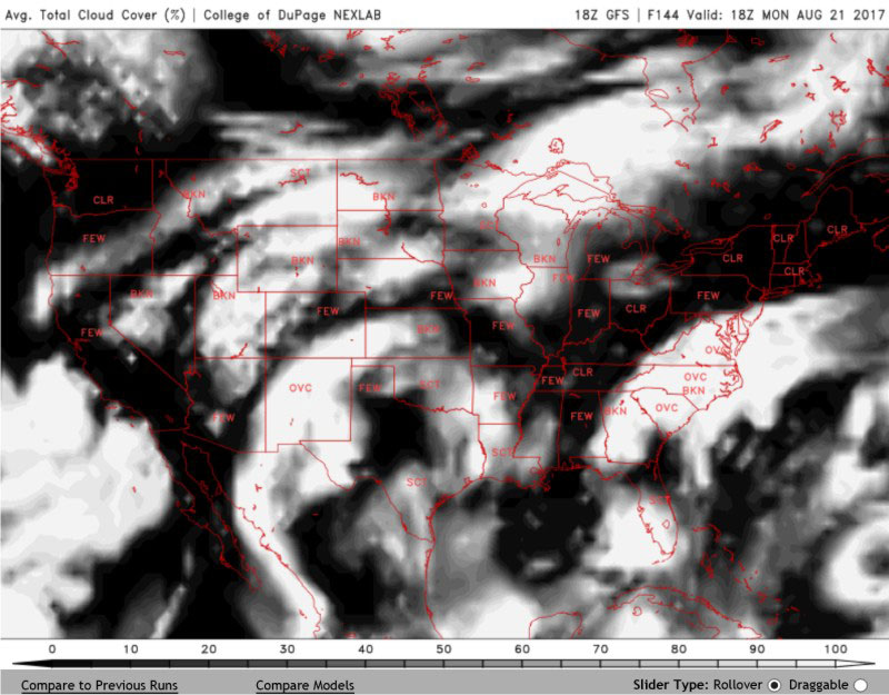
College of DuPage / NWS


Comments
BelmontJim
August 17, 2017 at 3:46 pm
Thanks for another informative post. I'll be based in Omaha and am still trying to figure out if there will be any decent skies to drive to along a swath from Missouri to western Nebraska. Trying to keep hope alive!
You must be logged in to post a comment.
You must be logged in to post a comment.