 3
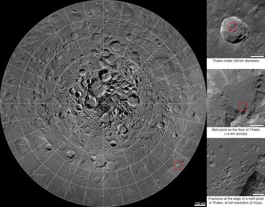
3With the first interactive lunar north pole mosaic released by the NASA’s Lunar Reconnaissance Orbiter Camera team you can explore an area of the Moon’s northern hemisphere about the size of Alaska and Texas combined.
NASA/Goddard/Arizona State University
The interactive mosaic consists of 10,581 images collected over four years of observations made by the Lunar Reconnaissance Orbiter (LRO). While the image above is a still, you can explore the interactive version here. The interactive map allows you to zoom in on craters and other features to amazing detail, and a list of notable features allows you to quickly pan and find fresh craters, impact melts, and even the tracks left by a boulder rolling down a crater’s central peak.
The LRO launched in June 2009 on a mission to map the surface of the Moon and scout out potential future landing sites and important science targets.
About two years into its mission, LRO changed its orbit from a near-circle to a highly elliptical path that crossed over both poles. The new orbit took the spacecraft closest to the lunar south pole and high above the lunar north pole. At such high altitudes the Lunar Reconnaissance Orbiter Camera (LROC), an instrument with narrow and wide angle cameras, was able to capture images of a vast amount of surface area. This led to a complete mosaic map of the Moon’s surface from 60°N to the geographic north pole with a resolution of 2 meters (6.5 feet) per pixel.
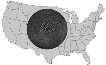
To put this in perspective, the area of the Moon that this mosaic allows you to explore is a little bit bigger than the size of Alaska and Texas combined — roughly an area of 2.54 million square kilometers (0.98 million square miles)!
NASA/LROC/Arizona State University
The LRO also released a half-gigabyte view of the moon in February 2011, but the huge interactive LROC Northern Polar Mosaic (LNPM) trumps its coverage by quite a lot.
If the soaring view of the Moon’s top half piques your curiosity, S&T has produced a full Moon globe based on 15,000 wide-angle LRO images, with labels for over 850 craters, valleys, lunar landing sites, and more.
About Emily Poore
Emily Poore is a freelance science writer with a bachelor's degree in physics and English literature (astronomy minor) and a master’s in publishing and writing. She currently works as a book editor in the Boston area. Find her on Twitter: @PooreWordChoice

Comments
Paul Schulte
March 21, 2014 at 3:34 pm
Fabulous mosaic! My first impression looking at the full view is that the terrain is much rougher near the pole. Is this appearance due to the lower sun angles from that region? Or some other aspect of the imaging process?
You must be logged in to post a comment.
Anthony Barreiro
March 21, 2014 at 3:41 pm
For those of us who enjoy looking at the Moon from our vantage here on Earth, the zero degree longitude line going from the center of this image down to the bottom edge is the center of the side of the Moon that faces Earth. The flat dark area at the bottom of this image is the northern edge of Mare Frigoris. Depending on the Moon's phase and libration, you'll be able to see more or less of this area, but you'll never see very far past the pole, and everything will be severely foreshortened. ----- In addition to S&T's Moon globe, the S&T Moon map, Charles Wood and Maurice Collins' 21st Century Atlas of the Moon, and the Moon Atlas mobile app are helpful moonwatching resources.
You must be logged in to post a comment.
Peter
March 21, 2014 at 9:45 pm
In Plaskett crater, a little beyond where the northernmost shadow of the central uplift points, a few hillocks sport a scatter-shot of white boulders, just visible at highest mag. They rise defiantly against the otherwise uniformly rounded terrain (lunain?). One area almost looks like a crowded observatory, the rocks perched on the hills like white domes.
You must be logged in to post a comment.
You must be logged in to post a comment.