 1
1Planetary geologists have used ground-penetrating radar aboard NASA's Mars Reconnaissance Orbiter to probe Marte Vallis, created during a catastrophic flood in the planet's geologically recent past.
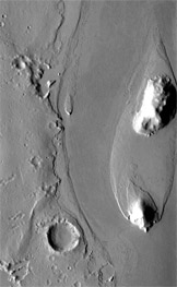
Marte Vallis was created during a catastrophic flood on Mars sometime within the past 500 million years. Note the streamlined island shaped by long-gone floodwaters. The crater at lower left is about 2 miles (3 km) across.
NASA / JPL / Arizona State Univ.
In its youth, Mars surged with geologic activity that included enormous, landscape-altering floods. While most of these torrents came and went eons ago, though, researchers have been intrigued by a large channel system named Marte Vallis that might have been gouged out much more recently. One problem is that much of the flood's path lies buried under lava flows.
Now NASA's Mars Reconnaissance Orbiter has allowed researchers to create a 3-D model that reveals the full scale and depth of Marte Vallis — including its buried portions — using a novel radar system able to penetrate deep below the Martian surface.
Based on the terrain it cuts across, Marte Vallis is believed to have been carved by a catastrophic flood between 10 and 500 million years ago (the uncertainty is large because dating surface events on Mars is notoriously imprecise).
"These channels are thought to be quite young," says Gareth Morgan, a geologist for the Smithsonian Institution's Center for Earth and Planetary Studies in Washington, D.C. Morgan is lead author of a report describing the radar work published in the March 7th edition of Science Express. "They could be on the order of 2 to 3 billion years younger than some of the other channels on Mars."
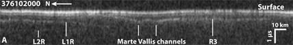
Subterranean probing by the SHARAD radar instrument on NASA's Mars Reconnaissance Orbiter has revealed flood channels buried deep beneath overlying lava flows. The radar waves reflected off at least three distinct layers (labeled L1R, L2R and R3.
G. A. Morgan & others / Science Express
Lying in a region of young volcanic flows known as Elysium Planitia, the upstream portion of Marte Vallis was filled in after it formed by thick lava flows. However, utilizing the orbiter's Italian-built Shallow Radar (SHARAD) instrument, which probes different layers of subsurface rock, Morgan and his team constructed a map of the original channel system that offers a detailed view of its 600 mile (1,000 km) expanse.
It now appears that Marte Vallis formed in two stages. The first resulted in a series of smaller branching pathways that wrapped around several streamlined islands. Then the floodwaters concentrated into a single trough that became deeper and wider than the rest. The radar profiles suggest that the channels' depths range from 230 to 360 feet (70 to 110 m), at least twice that of previous estimates.
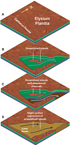
A fracture system called Cerberus Fossae (A) is the likely route that allowed a buried reservoir of water to repeatedly erupt onto the Martian surface. The floodwaters carved marte Vallis, first as a series of meandering channels (B) and then incising a deeper trough (C). Lava flows later filled in and buried much of the channel system (D).
G. A. Morgan & others / Science Express
As with the planet's other giant channels, the Marte Vallis floodwaters came from an enormous subterranean reservoir. Based on the new radar map, these waters appear to have surged onto the surface from Cerberus Fossae, a series of large, deep fractures that were also partially buried by lava. "We believe that these were the source of the ground water that created these flows," says Lynn Carter (NASA Goddard Space Flight Center), a co-author of the report. "Because there was volcanism in the area, perhaps it was warmer under the surface and so groundwater melted and formed this huge aquifer, and then suddenly it was released."
It's likely the flooding in Marte Vallis occurred rapidly, lasting weeks or months at most. A similar event, known as the Missoula Floods, devastated much of what is now Washington State when a glacial dam repeatedly broke during the last ice age and formed the present-day Channeled Scablands. Like the Missoula Floods, Marte Vallis probably filled with a raging torrent multiple times. "Because they show such dramatic power in terms of what's been eroded and what material's been moved, it's consistent that a small number of intense episodes occurred rather than a single ongoing event," explains co-author Jeffery Plaut, (Jet Propulsion Laboratory).
While SHARAD has previously been used to probe the icy polar regions of Mars, researchers expect that this instrument will prove useful in further explorations of Elysium Planitia. The area remains largely buried by lava flows, leaving much to be uncovered, including the ultimate termination of the Marte Vallis channels and any other recent signs of liquid water's presence on the Martian surface.
Michael Delaney is a graduate of Ursinus College with dual degrees in English and physics. He can often be found in his backyard looking at the night sky, eager to learn as much about the universe and its mysteries as possible.

Comments
John Wharton
March 22, 2013 at 3:17 pm
A somewhat hokey, yet compelling (at least to a geeky nine-year old) 1964 SciFi movie, "Robinson Crusoe On Mars" portrayed these very features under the surface of Mars, and to this level of detail. In fact, these were how the protagonists made their way to the south polar cap, for rescue. Nice to see life imitating art.
You must be logged in to post a comment.
You must be logged in to post a comment.