 8
8A well-traveled geophysicist recounts his curious findings at a prominent geographic benchmark in the Southern Hemisphere.
Sean Walker / Sky & Telescope
Most globes of Earth show four dashed lines that, aside from the equator, denote special latitudes related to the seasons. One of those, the Tropic of Capricorn, is the southernmost latitude at which the Sun shines directly overhead during the December solstice. It's currently at 23° 26′ 12.3″ south, a latitude that's decreasing (moving toward the equator) by 0.47 arcsecond (0.47″) per year.
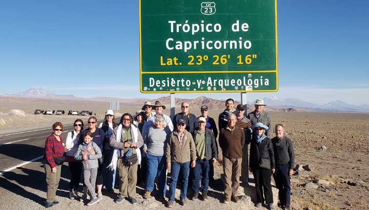
Last month, while on a Sky & Telescope tour to see this year's total solar eclipse, we stopped at a Tropic of Capricorn sign about 60 km south-southeast of San Pedro de Atacama, Chile, on Highway 23, and 50 km south-southwest of ALMA, the Atacama Large Millimeter/submillimeter Array of 66 radio telescopes high in the Andes.
The sign, shown above, reads "Lat. 23° 26′ 16″ [south]". It turns out that this was indeed the exact latitude of the Tropic of Capricorn in 2011. The sign is in good condition and might have been erected in 2011. So far, so good.
The GPS receiver on my phone, however, noted that the sign is actually located at about 23° 26′ 49.1″ south. That's about 1.13 km south of the current Tropic line. (I also measured the longitude to be 67° 59′ 44.1″ west.)
You might ask how accurate my GPS receiver is. Since the U.S. Air Force removed the "dither" from the GPS signal in 2000, single fixes on hand-held devices have had a 50:50 horizontal uncertainty of a few meters. (That is, about half of the fixes are within a few meters of the true location.) On a Google satellite image, the latitude and longitude of the Tropic monument on Highway 23 are within a few meters of the values measured by my GPS receiver.

Robert Kieckhefer
One uncertainty might be the geodetic datum, or global reference system, used by the Chilean government. In my experience working in various parts of the world (but not Chile), local geodetic datums rarely differ from the WGS84 ellipsoid by more than 100 meters.
So . . . I conclude that the Chilean highway department's workers did a sloppy job of locating the sign.
They aren't alone. In April 2019, I visited a Tropic of Capricorn marker in Namibia on road D1265, about 60 km west of Rehoboth. The sign, seen at upper right, was at 23° 28′ 0.3″ south, about 3.33 km south of the current tropic line. (The longitude was 16º 30′ 31.5″ east.)
Robert Kieckhefer
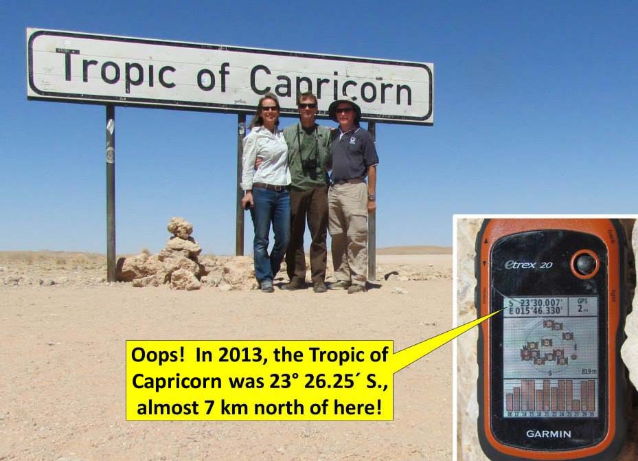
In 2013, I visited another Tropic of Capricorn sign on highway C14 in Namibia, about 140 km west of Rehoboth. It was at 23° 30′ 0.4″ south, almost 7 km south of the Tropic line. (The longitude was 15º 46′ 19.8″ east.) I presume someone read that the Tropic of Capricorn was "about" 23½° south and hence put the sign there. The turnoff for the sign is visible on Google satellite images.
So, at three signs marking the Tropic of Capricorn on highways in Chile and Namibia, not one was within a kilometer of the actual Tropic line. This is a bit disappointing, considering the ubiquity of hand-held GPS navigation devices for the past several years.
Moving to a slightly different topic (and back to the Northern Hemisphere), Wikipedia's Tropic of Cancer article has a photo of highway markers on Carretera 83 in Mexico, showing the equatorward movement of the Tropic line over 5 years.
About Robert Kieckhefer
Kieckhefer recently retired as a globe-trotting geophysicist for a major oil company and now has more time to indulge in his twin passions of eclipse-chasing and all-terrain biking.

Comments
Robert-Casey
August 20, 2019 at 2:38 pm
Wonder if farmers on the Tropic of Cancer grow tobacco? 🙂
You must be logged in to post a comment.
Peter Wilson
August 20, 2019 at 3:11 pm
While we're on the topic of cancer...
You must be logged in to post a comment.
Lou
August 21, 2019 at 8:38 am
I confess that the phrase 'Tropic of Capricorn' kinda/sorta sounds familiar but I have no idea what it is! The offset positions gives me an idea for a prank: I could visit Greenwich Observatory in London (2 hours from my house by train) and tell visitors that due to changes in time-keeping and movement of the Earth's crust, the true meridian line is now in the middle of the Irish Sea. I wonder how many would challenge my bogus assertion? 🙂
You must be logged in to post a comment.
Jim DeCamp
August 25, 2019 at 10:13 am
Back in the day, around four thousand years ago, on the day of the December Solstice, the sun was in the constellation Capricorn. These days it's on the western edge of Sagittarius, about 55 degrees to the west. The ancient Babylonians used centuries of observations of eclipses to track the position of the sun and knew where it was during the year. The dates of the solstices and equinoxes have drifted over the past 4000 years, as well as the houses of the Zodiac, but birthdates associated with them, and names of the tropics have been frozen in a time thousands of years ago.
Interestingly, the International Reference Meridian, the Prime Meridian, is about 102.5 meters east of where Airey's transit circle was in 1884, when the Greenwich Meridian was ratified as the Prime Meridian. When you visit the Royal Museums Greenwich, you can find a plaque memorializing this longitude and its significance.
You must be logged in to post a comment.
Rod
August 25, 2019 at 4:21 pm
Interesting report on astronomy history here. The Babylonians were geocentric and likely considered the Sun moved in a circle above the flat disk earth, perhaps attached to a solid dome structure. How did they calculate accurately the position changes of the Sun then? I ran a simulation software and checked the December Solstice of 2000 BC and this year December solstice, the reference to Capricorn and Sagittarius is correct. Modern astronomy does not calculate the position changes of the Sun like the ancients did.
You must be logged in to post a comment.
Jim DeCamp
September 2, 2019 at 4:08 pm
They determined the position of the sun by observing eclipses, both lunar and solar, and keeping records for centuries. Is is said that for the Babylonians astronomy was arithmetic, for the Greeks it was geometry. The Babylonians certainly understood the saros cycle, and knew the solar system was three dimensional.
You must be logged in to post a comment.
Rod
September 5, 2019 at 12:06 pm
Okay, I find it interesting that the Babylonians understood and *knew the solar system was three dimensional*. The Babylonian creation tablet shows the god Marduk made the firmament out of the body of Tiamat and placed the Moon there along with other heavenly bodies, so how far away was the Sun from the flat disk earth in their 3-D thinking or the distance to the Moon or the distance to Jupiter? The saros cycle was known but real precision like we have in the modern, heliocentric solar system did not exist, e.g. what areas of Earth would not see the eclipse or when lunar craters are covered up during lunar eclipses or the differences in solar eclipses and their durations. The ancient Egyptians in the Hymn to the Aton, written about 1365 BC, teach the Sun moves around the Earth like others in the Ancient Near East including treaties of Esarhaddon of Assyria. The exact number of Assyrian and Babylonian eclipse records that archaeology has uncovered and reliably dated, I have not seen a final tally. I enjoy ancient astronomy discussions but feel it is important to note that real differences in measurement and understanding of celestial motion took place when the heliocentric solar system was developed. Prior to 1672, no one knew the distance to Mars, thus the extent or dimension of the 3-D solar system in the ancient world was not known. Tycho Brahe attempted to measure the Mars parallax in the late 1500s but failed (Mars was too far away and the parallax to small for him to see). Cassini did in 1672 and the modern, heliocentric solar system and distances started to be worked out. Let us here cheers for the modern, heliocentric solar system 🙂
You must be logged in to post a comment.
Aaron
August 23, 2019 at 11:31 pm
I noticed the same thing when I was there. One other thing I noticed is that the road runs north/south, and so the signs for the Tropic of Capricorn on the east and west sides of the road should not be offset. But, as can be seen in your picture, they are offset by hundreds of meters.
You must be logged in to post a comment.
You must be logged in to post a comment.