 0
0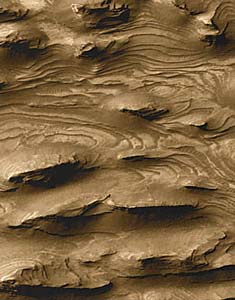
More than 1,000 evenly spaced beds have been counted in areas such as this. Their striking uniformity implies that the layering was created by cyclic events, possibly by volcanic ash deposits. Click for larger image (which is 1.5 kilometers wide).
NASA / JPL / Malin Space Science Systems
In December 2000, Michael C. Malin and Kenneth S. Edgett (Malin Space Science Systems) unveiled peculiar images taken of the red planet by the Mars Global Surveyor. The images revealed that thick stacks of layered deposits blanket large tracts of the Martian landscape — features that Malin and Edgett attributed to being formed within ancient lakes.
The hypothesis drew immediate criticism: for example, the craters containing the putative lakes lacked evidence showing how they could have become filled with water, nor did any streams or rivers breach the crater rims. Elaborate lake-filling theories were proposed, but none were ever widely accepted.
This week at the Lunar and Planetary Science Conference in Houston, Texas, a team of scientists from Washington University in St. Louis proposed an entirely different origin for the layered terrains — volcanic ash. The group, led by Brian Hynek, believe that early Mars was alive with volcanic activity. Among the most active of the smoking peaks were a group of mountains in the Tharsis region. Eruptions from these huge volcanoes would have sent up many huge plumes of ash, which in turn settled across the Martian landscape.
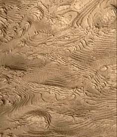
Multitudes of sedimentary layers fill part of a 64-kilometer-wide crater in western Arabia Terra in this image from Mars Global Surveyor. The ridges are generally a few dozen meters apart.
NASA / JPL / Malin Space Science Systems
Hynek and his team find that the layered deposits are thickest near Tharsis and thin out with distance. He also notes that depressions such as the deep Valles Marineris canyons tend to have large accumulations of ash. Both results are consistent with widespread ash fallout. The Valles Marineris canyons, for example, exhibit layers some 6 kilometers thick.
According to Hynek, this "closes the door that many of these [features] are lakes." In order to explain the layers, "You don't need to invoke water throughout Mars's history."

Comments
You must be logged in to post a comment.