 0
0In its first year on the Red Planet, NASA's Mars Science Laboratory has used its 17 cameras to record amazing scenery and its scientific operations.
It's been a full (Earth) year since NASA's Mars Science Laboratory — a.k.a. Curiosity — landed safely on the Red Planet's surface. The sophisticated rover's objective is to spend at least a full Martian year (98 weeks) studying the windblown deposits on the floor of Gale crater and the 3-mile-high stack of layered sediment not far away that could hold important clues to the planet's early history.
Curiosity spent much of that year relatively close to its touchdown site, which was renamed "Bradbury Landing" to honor the late, great science-fiction author Ray Bradbury. By the end of 2012, five months into its mission, the rover had traveled less than a half mile (several hundred meters), moving carefully toward intriguing exposures of bedrock dubbed Glenelg and Yellowknife Bay. These early sorties provided the mission's scientists and engineers with a variety of surface materials to fully check out the craft's robotic arm, drill, and instruments.
Finally, in early July 2013, the rover began to roll in earnest toward the lower slopes of Aeolis Mons (better known as "Mount Sharp"). But that objective is some 5 miles (8 km) away and likely won't be reached until well into 2014. Mission managers expect to take time along the way to explore local geologic outcrops that look interesting.
As the views below show, the terrain inside Gale crater is a fascinating mix of the alien and the familiar.
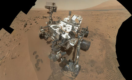
Curiosity used the Mars Hand Lens Imager at the end of its robotic arm to record this 55-image self-portrait amid an area called "Rocknest Wind Drift" on October 31, 2012 — the 84th Martian day, or sol, of its mission. The rover's robotic arm is not visible because MAHLI is on the turret at the end of the arm. At upper right is Aeolis Mons ("Mount Sharp"), the rover's ultimate destination. Click on the image for a larger, annotated view. NASA / JPL / MSSS |
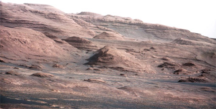
These sedimentary layers at the base of Aeolis Mons (also called Mount Sharp) are the key destination of Curiosity. In this enhanced view, part of a larger image taken by the rover's 100-mm Mast Camera on August 23, 2012, the mound at center is about 1,000 feet (300 m) across. Click on the image for a larger view. NASA / JPL / MSSS |
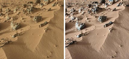
This pair of images from the Mast Camera on NASA's Curiosity rover shows a portion of a wind-blown deposit dubbed "Rocknest," where the rover has scooped up a sample for analysis by its Chemistry and Mineralogy instrument, or CheMin. The colors in the image at left are unmodified, showing the scene as it would appear on Mars, which has a dusty red-colored atmosphere. The image at right has been white-balanced to show what the same area would look like under the lighting conditions on Earth. Click on the image for a larger version. NASA / JPL / MSSS |

A patch of rock, dubbed "Ekwir 1", seen before and after it was brushed clean by Curiosity's Dust Removal Tool (DRT) on January 6, 2013. The rover's arm-mounted MAHLI camera took these images. The cleared rock surface is about 2.4 inches (62 mm) wide. Click on the image for a larger view. NASA / JPL / MSSS |
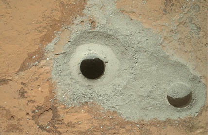
At center left is the first full-depth hole drilled on Mars by Curiosity on February 8, 2013. About 0.6 inch wide and 2.5 inches deep, it was made in a sedimentary rock called "John Klein". At right is a shallower hole created during a test of the drill two days earlier. Click on the image for a more detailed view. NASA / JPL / MSSS |
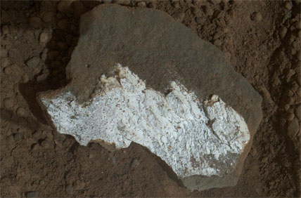
In January 2013, the rover rolled over a small, dust-covered rock and broke it open, exposing a whitish interior. Dubbed "Tintina", the fragment is about 1½ inches (4 cm) wide, and its interior looks much like similarly bright material filling pale veins in the nearby bedrock of the "Yellowknife Bay" area. This close-up was taken by the rover's Mars Hand Lens Imager. Click on the image for a larger view. NASA / JPL / MSSS |
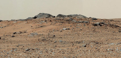
By July 24, 2013, its 343rd sol (Martian day) since touchdown, Curiosity had rolled about 1,500 feet (500 m) southwest from Glenelg and toward Aeolis Mons. The rover paused briefly to let its Mast Camera snap a panorama of seven frames that includes this 10-foot-wide outcrop of gray rocks, named "Twin Cairns" by mission scientists. This scene has been white-balanced to show how it would look on a sunny day on Earth. Click on the image for a large version of the entire panorama. NASA / JPL / MSSS |
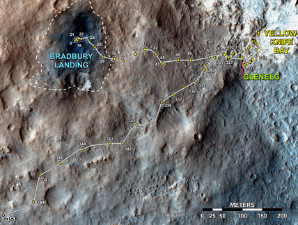
From its landing at 5:32 Universal Time on August 6, 2012, through August 1, 2013 — the mission's 351st Martian day — Curiosity drove 1.05 miles (1,686 m). Most of that time was spent exploring interesting geologic outcrops in areas dubbed Glenelg and Yellowknife Bay. But in early July the rover started moving purposefully toward the lower slopes of Aeolis Mons, about 3 miles (5 km) away. Click on the image for a larger version. NASA / JPL / Univ. of Arizona |
About Monica Young
Monica Young, a professional astronomer by training, is News Editor of Sky & Telescope.

Comments
You must be logged in to post a comment.