 0
0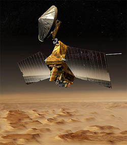
Although it arrived at the Red Planet in March 2006, the Mars Reconnaissance Orbiter didn't begin its science mission until reaching its final orbit eight months later.
Kelly Beatty
By the time NASA's Mars Reconnaissance Orbiter (MRO) arrived at the Red Rlanet one year ago, planetary specialists around the world were already salivating at the prospects for a scientific bonanza. On board is HiRISE, the largest camera ever flown to another world, which can resolve Martian surface features less than 1 meter across with images up to 20,000 pixels on a side. Another key instrument is CRISM, an incredibly powerful spectrometer able to distinguish mineral deposits just 18 meters across. The spacecraft is also equipped to monitor the planet's poorly understood climate and to probe its subsurface secrets with pulses of radar energy. More than 1 terabyte (a million million bits) of those data are being beamed toward Earth every month — a mind-boggling glut of fresh information.
But the orbital space around Mars is getting crowded with spacecraft, including an instrument-packed European craft, Mars Express, that has been beaming back high-resolution stereo pictures, mineral spectra, and radar soundings since its arrival in late 2003. NASA's Mars Odyssey orbiter and the twin Mars Exploration Rovers (Spirit and Opportunity) continue to vie for scientists' attention as well.
With all that competition, would MRO live up to its high scientific hopes? Last week a standing-room-only crowd of planetary scientists filled the main hall at the Lunar and Planetary Science Conference in Houston, Texas, to find out. And they weren't disappointed. Some highlights:
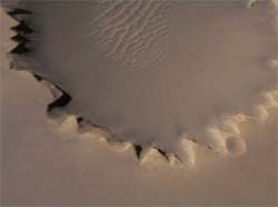
Victoria crater, home to the Opportunity rover, was an early target for the HiRISE camera on NASA's Mars Reconnaissance Orbiter. Click on the image to download a 5.0-megabyte QuickTime flyover of the crater created using HiRISE imagery. Lower-resolution versions are available as 2.8-MB and 1.2-MB downloads.
Kelly Beatty
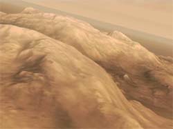
Another simulated flyover, created using HiRISE images, depicts the Columbia Hills, currently being explored by the Spirit rover. Click on the image to download a 7.4-megabyte QuickTime flyover of the crater created using HiRISE imagery. Higher-resolution versions are available as 4.4-MB and 2.2-MB downloads.
Kelly Beatty
Meanwhile, team scientists reported that MRO's weather camera, the Mars Color Imager (MARCI), is working well and has already revealed water-ice clouds nucleating on dust. With MARCI, scientists can watch how Mars's weather changes over the course of just hours, with particular emphasis on the evolution of weather systems, cloud formation, and dust storms.
MRO has a radar sounder, named SHARAD, that uses waves of radio energy to penetrate the ground and looks for the reflections that signal the presence of water (liquid or ice) under the surface. It operates at a wavelength complementary to that of Mars Express's MARSIS instrument, probing to shallower depths but with higher resolution. Thus far scientists have concentrated on determining the extent of the frozen reservoirs buried under the Martian poles.
Not all the news was upbeat, however. MRO's Mars Climate Sounder, which studies the atmosphere's temperature, humidity, and dust, has a balky motor and has had trouble tracking. The instrument might ultimately help scientists to better understand the seasonal cycle of dust and water vapor condensation, but for now it is only observing the planet's limb. The ultimate status of the motor will be determined in the coming months.

Comments
You must be logged in to post a comment.