 2
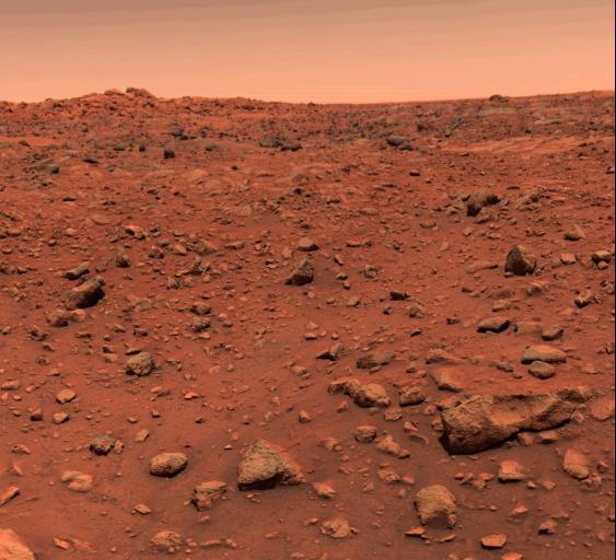
2Long-ago impacts tossed up the floors of an ancient ocean on the Red Planet and carried debris to the landing site of NASA’s Viking 1 lander.
NASA / JPL
Scientists have traced the source of mysterious boulders found near the site of the first successful Mars landing — NASA’s Viking 1 — to a partly buried crater about 900 kilometers northeast of the landing site. The impact around 3.4 billion years ago came in an ocean deep enough to produce a mega-tsunami that ripped up debris from the surrounding area and carried those rocks up onto the shore.
Evidence that water once flowed on Mars led NASA to place its Viking 1 lander in the Chryse Planitia, a low-lying circular plain north of the Martian equator on July 20, 1976. The goal was to look for signs of life near an ancient water flow; however, rather than seeing signs of water, planetary scientists found strewn boulders. There was no clear evidence how the boulders got there, which made their presence "an enduring mystery in planetary exploration," says Alexis Rodriguez (Planetary Science Institute).
Now, Rodriguez, who has been studying it for years, has led a team in solving that mystery.
Ancient Impacts
On Earth, geologists discovered 65 million-year-old tsunami deposits in Texas and around the Caribbean decades ago. They deduced that these deposits came from the impact of a 10-kilometer (6-mile) asteroid, showing that giant tsunamis could carry debris long distances. But it took a determined search to find the 180-kilometer Chicxulub Crater along the Yucatán Peninsula.
Similar processes might have occurred on Mars, bringing water past the typical shoreline. But changes in climate altered the altered the shoreline significantly over time, and we have data for only small parts of the intervals when Mars had oceans.
In 2016, Rodriguez and colleges reported evidence of two separate mega-tsunamis around 3.5 billion years ago in the ancient ocean that then covered the north of the Red Planet. The interval between the tsunamis was “long enough for glaciation to cut deep valleys along the boundary, but quantitatively unconstrained,” says Rodriguez. During that interval, the ocean shrank and Martian climate cooled considerably, changing the shorelines extensively and complicating the search for an originating crater.
More recently, Rodriguez’s group modeled the effects of Martian impacts by asteroids of different sizes on different types of rock to search for the impact site. In the December 1st Nature Scientific Reports, the team reports the most likely suspect for the first impact: a 110-kilometer crater named Pohl (after science fiction writer Frederik Pohl), located about 900 km northeast of the Viking lander site.
“The mega-tsunami deposit extends far inland from the estimated paleoshoreline elevation, so we know that the wave must have been highly energetic,” says Rodriguez.
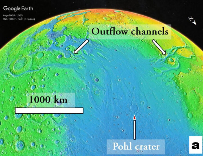
MOLA Science Team / MSS / JPL / NASA / Google Earth / PSI
Debris Flows
The model shows that the impact ejecta would have fallen fairly near the crater, rather than being blasted all the way out to the Viking site. Although some ejecta might have been caught up in the giant wave, the post-impact shock wave would have generated more debris carried by the tsunami.
“The marine floors would have been tossed up,” Rodriguez says, “feeding the wave with sediments and probably aiding the development of a catastrophic debris flow front.” The wave initially reached a height of about 500 meters (1,640 feet) and propagated inland to some 250 meters above sea level, aided by the low slope of the terrain. Immediately afterward, the low slope would also have slowed any backwash, keeping most of the debris on land.
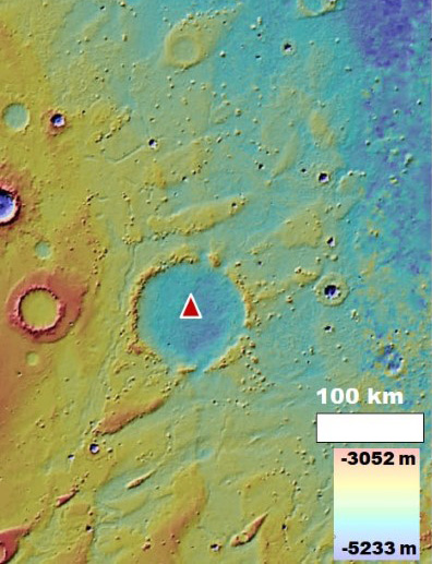
MOLA Science Team / MSS / JPL / NASA
When the second impact came later on, the tsunami it produced covered Pohl Crater. Both events happened during the Late Hesperian, a Martian epoch that lasted some 230 million years around 3.4 billion years ago. The exact timing of the impacts and the interval between them is still uncertain.
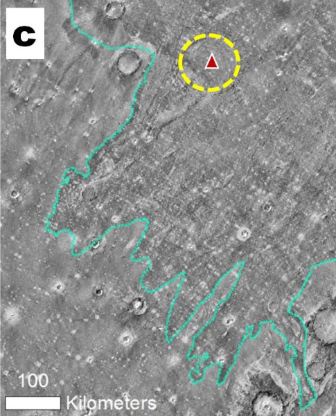
P. Christensen et al. / THEMIS Public Data Releases 2006
This further support for impact-induced tsunamis on early Mars, “supports the hypothesis that Mars once had oceans,” says Robert Citron (UC Berkeley), who was not involved in the study. “[Such tsunamis] would have required a standing body of liquid water within Mars’ lowland northern basin to form.”
Although changes over the intervening 3.4 billion years complicate interpretation, Citron says, “hypothetical shoreline and tsunami deposits are attractive targets for future missions because of their implications for early Mars habitability.”
About Jeff Hecht
Jeff Hecht writes about science and technology, with a particular interest in all things optical. He first discovered Sky & Telescope when he was 10, and he still has the one-inch Wollensak refractor his father gave him then.


Comments
macnevin
December 10, 2022 at 4:43 pm
The so-called tsunami deposits along the coast of Mexico are normal fluvial deposits. The authors of the original article have acknowledged this.
The flat region of Mars shown in the colour photo from 1976 shows "no sign of running water". This is NOT evidence of Tsunami deposits.
Let's go to Mars but let's not push the water thing too far. volcanic processes must be considered.
You must be logged in to post a comment.
Monica Young
December 12, 2022 at 10:08 am
This response is from the post author, Jeff Hecht:
The authors recognized there was no sign of running water in the 1976 images, but their paper said that neither were there signs of volcanism. Their explanation was that the tsunami washed the boulders over an area that was nearly flat, so the water receded slowly, not rapidly enough to leave obvious fluvial deposits. I didn't have room to include those details in my story. However, I do agree that the area deserves further exploration, which often finds the details are more complex than had been proposed by any previous explanation.
You must be logged in to post a comment.
You must be logged in to post a comment.