 0
0With the eclipse just a few days away on Monday, now is the time to start taking stock of the weather forecast — and making decisions.
Edward Foster
Saturday. Sunday. Eclipse day.
It’s time to make some early decisions about eclipse day. The numerical models that predict the cloud cover for eclipse day are still in partial disagreement about Monday’s weather but the major details have been worked out. Now it’s your turn to work out a general plan.
America can be divided into two weather regimes on Monday — those that will or may be affected by convection (thunderstorms) and those that will not. The models agree in detail, about the latter group: Oregon, Idaho, and western Wyoming. For the rest, where August is still thunderstorm season, the only agreement is that there will be a mixture of sun and cloud and you will have to do your homework.
First, the good news: Oregon and most of Idaho look just fine. All models that I’ve seen (four of them, from the U.S., Canada, and Europe) give these states cloud-free skies. The models also agree on the weather along the Idaho-Wyoming border: an upper-level system will be going by and the eastern parts of Idaho and western Wyoming will be cloudy. Those models aren’t in complete agreement on the amount of cloud, but those of us in the Jackson Hole area are now confronted with the need to make a “Plan B.”
For the rest of the eclipse track east of Wyoming, Figure 1 pretty much says it all. This view of the cloud cover is from the North American Model (NAM) provided by the National Weather Service (NWS); you can see that it’s a pretty messy-looking scene across the country, from Nebraska to the Atlantic coast. If you ignore everything except what’s on the eclipse track, there are only a few areas of heavy cloud, mostly over Illinois and the Carolinas. The rest of the track is more “speckled” with clouds. These speckles, and some of the heavier cloud areas, are convective clouds, some of which are pretty active, such as those over Nebraska.
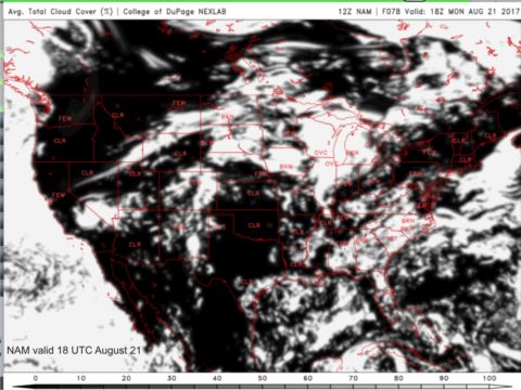
College of DuPage, NWS
The biggest problem with making a decision based on this image is that it will change between now and the next model run, and then change again with the one after that. To compound that uncertainty, other models will offer different solutions that will be generally similar, but different in the details for your site. If you want to see those models yourself, see my blog from Wednesday. It will show you how to reach the College of DuPage model site from my website and how to go from there.
But most of us have a viewing location already planned, and we want to know what’s up there. I like a rather nifty site called spotwx.com that will give you a very precise forecast from the models for your location, right down to your house, if you know the latitude and longitude coordinates. Just go to spotwx and type in a city name, click on the map, or insert geographical coordinates, and the menus on the left side of the page will be tailored to your specific needs. Those left-side icons are the names of various models, but the ones you will want to examine are the NAM, the GFS, the GDPS, and the RDPS (the last two are Canadian models). For starters, pick the NAM.
When you click on one of the model icons, you will be presented with a page of graphs, one of which will show the predicted cloud cover at three-hour intervals. Check it out for eclipse day for your site. Then go back and check out the other model predictions. If they all look pretty similar then you can have a little bit of confidence in their version of the future. Figure 2 shows the forecast for Nashville from several models.

spotwx.com/NWS/Environment Canada
If your chosen site is forecast to be cloudy, try looking at some nearby sites, perhaps based on the cloud maps from the CoD site. I did that for Jackson, WY, which is forecast to be cloudy, and found that Moran, a few miles north, is expected to have cleared the cloud ahead of eclipse time. That opens up another Plan B for me, though I’ll keep checking back through the weekend to make sure it’s still viable.
By Sunday afternoon and evening, models won’t be of much use because the weather will be on your doorstep. There is a very short-range model called the RAP that shows cloud cover, but it only goes out for 21 hours into the future. Instead, your attention should turn to the satellite images available at the CoD site and elsewhere. Pick “1 km” or “2 km” from the left-side tabs and then the region for where you want images from the map that appears. At night, you’ll have to use infrared (IR) images, but by looping the display, you’ll be able to see how clouds are moving and changing. This is only good for short-range, limited movement, but it at least is “real” information instead of “virtual” information.
Because so much of the weather across the eclipse track is convective in nature, cloud forecasts are subject to a great deal of uncertainty. In the end, you may have to scan the horizon and decide to “go over there.” At the least, the model forecasts and the satellite images will have you prepared for the final hours before the eclipse.
About Jay Anderson
Jay Anderson has been looking at eclipses and eclipse climatology for nearly 30 years, helping to make the shadow experience more rewarding (and more certain) for those inclined to stand within the umbra. See more of his climatology and weather for celestial events at eclipsophile.com.


Comments
You must be logged in to post a comment.