 0
0Evidence for water ice exists at the poles of Mars and even at mid-latitudes, but new evidence suggests “tropical” Mars (near the equator) is dry. The find has implications for past habitability and future human missions to Mars.

NASA / JPL-Caltech
Hardly any traces of the vanished oceans of Mars remain in the Red Planet's tropics. The velocity of seismic waves recorded by the seismometer in NASA's InSight lander reveal few traces of the subsurface ice that has been found at higher latitudes, says oceanographer Vashan Wright (University of California, San Diego). Wright led the study published August 9th in Geophysical Research Letters.
We now know ancient ocean and rivers sculpted the Martian landscape — and that some of this water remains in the form of kilometers-deep ice atop the poles. Water ice is not stable at lower latitudes, but in recent decades researchers have found some ice, which froze during colder epochs, preserved under the surface. Water that evaporated can also leave behind deposits of clays and soluble minerals on ancient rocks; the Osiris-Rex spacecraft discovered similar traces of past water on asteroid 101955 Bennu.
Hidden ices and minerals deposited by water can offer important insight into the history of Mars and the possibility that life might once have evolved on it. NASA is also searching for existing ice and water deposits to help supply future human expeditions to the Red Planet. Although ice is abundant at the poles, conditions there are too harsh for humans, so NASA is focusing on lower latitudes where ice may be below the surface.
Last year, the Mars Subsurface Water Ice Mapping (SWIM) project reported that shallow ice deposits are plentiful at high and mid latitudes. The team gathered indirect evidence using neutron spectroscopy, heat-flow measurements, geomorphic analysis, radar mapping, and radar composition analysis. The most definitive evidence came from recent impacts that exposed bright white areas of previously buried ice.
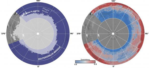
Morgan et al. / Nature Astronomy 2021
“We use the location of fresh ice-exposing impacts . . . to ground-truth our approach,” says Gareth Morgan (Planetary Science Institute, Washington), lead author of the report published a year ago in Nature Astronomy. Icy spots have been observed in craters as close as 39º to the equator, and a few potential signs of ice have been observed at slightly lower latitudes, says Morgan.
The landing of InSight November 26, 2018 in Elysium Planita, 4.5º north of the Martian equator, brought a new capability — the first seismometer to operate on the planet since the Viking landers attempted similar operations on Mars in 1976. The new instrument takes advantage of four decades of new technology, and Wright realized it could help in the search for subsurface ice.
Seismometers measure vibrations in the ground, whose speed depends on the materials they’re passing through. Wright's idea was to use the seismometer to detect ice, as well as minerals that ice might leave behind, in the rock. The area where InSight landed is dominated by two materials, loose sediments, in which seismic waves move slowly, and fractured basalts, which transmit the waves faster.
“One of the things we looked for was carbon dioxide acting a cement to glue the grains together,” says Wright. Carbon dioxide from the atmosphere dissolved in the ancient ocean, then was buried as an aqueous solution, where it reacted with surrounding grains to form calcite (a form of calcium carbonate). Calcite glued these sedimentary grains together, which now lets seismic waves travel faster through the material. The same effects could have occurred in the fractured basalt, which might also hold some ice.
Using the seismic wave data, Wright's group analyzed the structure of InSight’s landing site. They refined the results by running computer models of seismic wave propagation 10,000 times. While they did not directly detect ice, water, or cement, by comparing their models with the InSight data, they were able to show the maximum levels of ice, water, or cement that could be present — and they were low.
The group found no evidence of water or ice in the sedimentary layers, down to 300 meters (1,000 feet) beneath the lander. The cracks among the fractured basalts make up less than 40% of the volume, and those cracks are largely filled with air — they contain less than 20% ice and less than 2% calcite cement.
The failure to find evidence for ice did not surprise Morgan. “[It] doesn't really challenge our current thinking about the location . . . of accessible ice,” he says. “But it does demonstrate the importance of surface geophysical instruments to test the results of orbital and model-based analysis. It would be wonderful to place seismometers at higher latitudes on Mars.”
About Jeff Hecht
Jeff Hecht writes about science and technology, with a particular interest in all things optical. He first discovered Sky & Telescope when he was 10, and he still has the one-inch Wollensak refractor his father gave him then.


Comments
You must be logged in to post a comment.