 0
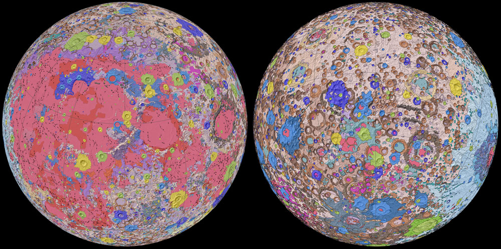
0The U.S. Geological Survey (USGS) has released a new 1:5,000,000 map of the Moon that provides a wealth of information about its surface.
NASA / GSFC / USGS
The U.S. Geological Survey (USGS) has released a new map of the Moon — and the glimpse above only hints at its riches. If you want to see the map in full detail, and a full legend showing what the colors indicate — both highly recommended! — you can download it from the agency's website.
To create this map, scientists at the USGS used information from six Apollo-era regional maps along with data from satellites orbiting the Moon. Existing historical maps were redrawn to align them with the modern data sets, thus preserving previous observations and interpretations.
In addition to merging new and old data, USGS researchers also developed a unified description of the stratigraphy, or rock layers, of the Moon. This resolved issues from previous maps where rock names, descriptions, and ages were sometimes inconsistent. This unified classification scheme is depicted as 48 different types of units on the map, shown as 48 colors.
“This map is a culmination of a decades-long project,” said team lead Corey Fortezzo (USGS) in a press release. “It provides vital information for new scientific studies by connecting the exploration of specific sites on the Moon with the rest of the lunar surface.”
Just as previous lunar maps served as blueprints for the Apollo missions, this map will serve as an essential reference for future lunar science and exploration.
About Monica Young
Monica Young, a professional astronomer by training, is News Editor of Sky & Telescope.


Comments
You must be logged in to post a comment.