 0
0There could be liquid water trapped under the southern polar cap of Mars. But new observations suggest otherwise.

ESA / DLR / FU Berlin / Bill Dunford
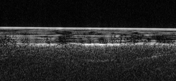
There is an ongoing scientific battle about the potential existence of a body of liquid water, a subglacial lake, buried almost 1 mile (1.5 kilometers) beneath the south polar ice cap of Mars. New radar data now suggest this lake might not exist.
The possibility of a Martian subglacial lake was first proposed in 2018, to explain observations from the Mars Advanced Radar for Subsurface and Ionosphere Sounding (MARSIS) instrument aboard the European Space Agency's (ESA) Mars Express orbiter. The MARSIS team detected a highly reflective radar signal originating deep underground, at the boundary between the deepest layers of ice and dust above the Martian bedrock . Since liquid water reflects radar strongly, and because only very salty water could remain liquid at the extremely cold subsurface temperatures, the initial detection was interpreted as evidence for the presence of salty, underground lakes on Mars.
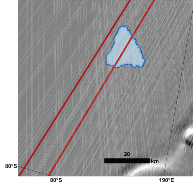
ESA / NASA / JPL / ASI / Univ. Rome; R. Orosei et al. 2018
Similar lakes have been found under Antarctic ice on Earth, so the idea is not as otherworldly as it might seem. On Earth, researchers have even drilled through kilometers of ice to reach these lakes and extract water samples. Surprisingly, microorganisms in those samples are doing just fine. So the idea of a microbiologically active pocket of water tucked under Martian ice was appealing to astrobiologists.
But now, new radar data from a different spacecraft in Mars orbit has peered through the thick ice layers again. Where Mars Express saw a strong reflection, NASA’s Mars Reconnaissance Orbiter (MRO) has only seen a weak signal. A team of scientists used MRO’s Shallow Radar (SHARAD) instrument, which is optimized for higher-frequency near-surface imaging. The findings are described in a paper published in Geophysical Research Letters on November 17th.
SHARAD operates at a higher frequency than MARSIS, providing better resolution but sacrificing penetrating power. Additionally, the instrument’s dipole antennas are placed on the back of the MRO spacecraft — a design compromise since the most valuable real estate in the front was reserved for more valuable scientific assets, such as cameras. These limits explain why scientists haven’t used it to peek at the subglacial lakes until now, despite its almost 20 years of operation.
To overcome these limitations, the MRO team devised a maneuver they call a “very large roll,” where they basically turn the spacecraft on its side, beaming the radar signal directly to the planet to get a stronger return. Using this strategy, researchers increased the power transmitted towards the surface tenfold and were finally able to probe the base of the ice cap at the exact location of the strong MARSIS reflection.
“Rolling the spacecraft is risky,” says team lead Gareth Morgan (Planetary Science Institute). “When you roll the spacecraft you're also rolling the solar array and that means you're not getting energy.”
To avoid losing valuable sunlight that powers the solar-paneled spacecraft, the rolling maneuvers are only performed at night. Since the only time when the spacecraft is in darkness over the poles is during the winter solstice, that’s when the team performed this acrobatic observation. “It was a very hard observation,” Morgan says. “We had very tight time constraint, and a very small area on the surface [to observe].”
Planetary Science Institute
However, they didn’t find what they were looking for. Instead of the bright, strong reflection expected from a liquid water layer, the instrument registered only a faint signal. A subsequent very-large-roll observation of an adjacent area failed to detect any distinct signal at all. This suggests that the strong reflection that MARSIS observed may be a localized anomaly, perhaps caused by a rare patch of smooth surface — such as an ancient lava flow — within the irregular terrain below the ice cap.
NASA / JPL-Caltech
The lack of a strong reflection on SHARAD data, however, does not definitively settle the question of whether the subglacial lake exists. Roberto Orosei (National Institute of Astrophysics, Italy), lead author of the 2018 MARSIS study, notes that SHARAD is operating at the absolute edge of its capability at such depths, even with the special maneuvers. Despite the absence of a strong reflection, a liquid water layer might still exist but simply be too faint for the high-frequency SHARAD radar to detect.
In fact, Orosei says that his team had already predicted back in 2020 that at the higher frequency at which SHARAD operates, radar attenuates faster as it penetrates the ice. So a much weaker return signal from the boundary was to be expected. Their signal, Orosei says “is in the range we predicted based on what we knew at the time.” At the moment, “we are verifying their computations,” Orosei says.
Even if the subglacial lake question is not settled yet, MRO’s very large roll technique offers new opportunities to investigate other scientifically interesting regions of Mars. For instance, the researchers could better investigate the volcanic history of the planet. Volcanic rock absorbs radar signal quickly, so it’s difficult to peer beneath the surface. With a stronger signal, the instrument could see deeper underground. “This new technique will allow us to probe deeper into these volcanic regions and maybe get new insights there as well,” Morgan says.
The same principle applies to searching for hidden ice deposits beneath the surface in equatorial regions. “We hope that this will increase the areas we can detect ice and maybe improve our ice maps,” Morgan says. Astronauts could potentially use these water deposits in the future.
About Javier Barbuzano
Javier Barbuzano is a bilingual Spanish-English science writer and communicator. He graduated from Boston University with a master’s degree in Science Journalism. He writes about many topics, but astronomy and technology are his favorites.


Comments
You must be logged in to post a comment.