 3
3Scientists reported interesting findings about Mars this week, and for a change the news didn't involve the landers Phoenix, Spirit, or Opportunity.
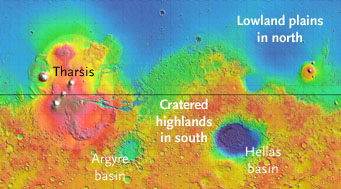
Mars exhibits a puzzling dichotomy: much of its southern hemisphere is ancient, heavily cratered highland terrain (colored orange and red in this cylindrical map of elevations), but its northern half is dominated by flat, low-lying plains (green and blue).
NASA / MOLA Team
The first report comes from Mars Odyssey, which has been in orbit there since October 2001, and revives the idea that a vast expanse of water once covered up to a third of the Red Planet's surface. Roughly 10 times the size of the Mediterranean Sea, this alien ocean would have occupied much of the northern half of Mars, which is smooth, flat, and low lying — in stark contrast to heavily cratered highlands in the south.
In the late 1980s Timothy Parker, a Mars specialist at the Jet Propulsion Laboratory, turned up what appeared to be vestiges of ancient shorelines in Viking images. But the details were subtle and furtive, and enthusiasm for a paleo-ocean waned over the years as higher-resolution images from later spacecraft revealed little where Parker had looked.
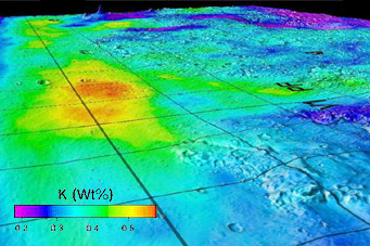
This map, which combines Mars's topography with a colored overlay of potassium abundance, marks the boundary between the planet's northern lowlands (left) and its Elysium highlands (right). Enhanced potassium in the lowlands (0.5% or more) might indicate the presence of seafloor sediment from an ancient Martian ocean. The labels "V1" and "MP" at right denote the landing sites for Viking 1 and Mars Pathfinder.
NASA / JPL / Univ. of Arizona
But now scientists from the University of Arizona and elsewhere report that there might be something to the ocean idea after all. Again the evidence is subtle — nothing so obvious as gigantic seashells — emerging from geochemical signatures of the rocks themselves. Based on a global survey of elemental abundances compiled by Odyssey's gamma-ray spectrometer, there seems to be more potassium, thorium and iron in the putative ancient seabed than in the higher terrain that surrounds it.
Why should that be the case? James M. Dohm (University of Arizona), who led the work, explains in a press release that these three elements should be more concentrated within seafloor sediments because water flowing out of the southern highlands would have leached the elements from planet's ancient crust.
These days most planetary scientists think Mars has been in a bone-dry deep freeze for most of its history. Yet the planet does have plenty of water stashed away as ice. Victor Baker, one of Dohm's Arizona coauthors, has long argued that Mars has been sporadically wet and warm, but he's failed to sway most other scientists.
Is the jury still out in "The Case of the Martian Ocean"? Let's see what kind of reaction ensues when the Mars Odyssey work appears in a forthcoming issue of Planetary and Space Science.
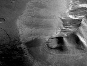
A mountain in the eastern Hellas region of Mars appears surrounded by apron-shape flows that, based on radar probing, contain abundance ice. This image was acquired by the High Resolution Stereo Camera (HRSC) on the Mars Express spacecraft.
Science / Univ. of Texas / ESA / DLR / FU Berlin
Meanwhile, more detective work by orbital spacecraft reveals that that a glacier's worth of ice appears to lie just under a thin veneer of topsoil. This finding wouldn't ordinarily be news — after all, Phoenix landed atop a thinly disguised slab of frozen water, and previous work suggests that buried ice likely extends for hundreds of miles beyond both of the planet's polar caps.
However, an article appearing in today's issue of Science argues that glaciers of ice also lie buried lie near the giant basin Hellas at a southern latitude of 45° — much closer to the planet's equator than previously thought possible.
The stealthy glaciers were revealed by radar soundings from NASA's Mars Reconnaissance Orbiter. Tens of miles long and and up to a half mile (1 km) thick, they're probably remnants from an ice sheet covering the planet's middle latitudes during colder climes. Since then they've been capped by a layer of dusty debris, which insulated them from direct sunlight.
You'll find a nice summary of the Science paper, written by John W. Holt (University of Texas at Austin) and 11 others, in this online press release. Detailed images of the suspected glaciers (and a 97-megabyte animation) are here.
About J. Kelly Beatty
J. Kelly Beatty, S&T Senior Editor, joined the staff of Sky Publishing in 1974 and specializes in planetary science and space exploration. Learn more about him here.


Comments
William
November 21, 2008 at 10:34 am
One day, we'll take a trip to mars for a vacation. Martian income will be Industry and Tourism.
You must be logged in to post a comment.
Ron Skurat
November 22, 2008 at 11:57 am
The thing I don't get about these deposits is why they would form/settle at the foot of a mountain. It's as if a low cloud layer dumped its snow as soon as it encountered any elevation, or that ice formed on mountain peaks & slid down as glaciers.
I suppose trying to make analogies to earth conditions is futile, considering the radical differences btw the two atmospheres - but can anybody come up with another mechanism for a weird feature like this?
You must be logged in to post a comment.
Rick Smith
May 16, 2012 at 9:37 am
The link below this message leads to an article documenting an analysis of purported shorelines showing that a appropriately shaped ocean figure would fit the shorelines. Clifford and Parker mapped shorelines for two major ocean-sized areas in their paper: ("The Evolution of the Martian Hydrosphere: Implications for the Fate of a Primordial Ocean and the Current State of the Northern Plains" Icarus 154, 40-79 (2001); Stephen M. Clifford, Lunar and Planetary Institute; Timothy Parker, Jet Propulsion Laboratory)
These lines can be fitted with oceans without crustal distortion using only appropriate gravitationally induced tidal bulges. The lines can be likened to "bathtub rings" in the northern basins on Mars. The analysis, which uses MOLA data to create an accurate three dimensional model of Mars, is virtual physical evidence that the purported shorelines are the result of large bodies of water - or ice - on the Martian surface. The lines are equipotentials.
The analysis was first published on the internet in January 2009.
http://marsshorelines.zxq.net/
You must be logged in to post a comment.
You must be logged in to post a comment.