 4
4Weather will play a crucial role on eclipse day. Meteorologist and eclipsophile Jay Anderson shares his tips for predicting the unpredictable: eclipse weather.
Michael Zeiler / greatamericaneclipse.com
Once upon a time, August 21, 2017, seemed a long way off. Now here it is, on our doorstep. Long-range planning is being replaced with immediate concerns: reservations, travel, photographic possibilities — and, of course, the weather.
I know some of us have already been peeking at satellite images or calling up online forecasts for our chosen destinations, looking for clues about the 21st. And some don’t really care too much – if you already live under the eclipse’s shadow track, you may want to just take what comes on eclipse day. As a meteorologist, I know that predictions have a dubious record of success, but I’ll make one prediction that’s a slam dunk: When eclipse day is only one or two days away, you will care about the weather.
I can’t give you even a fuzzy picture of eclipse day weather just yet, but we can explore some of the possibilities over the next three weeks by looking at the weather today and in days to come and working out some “Plan B” strategies. Along the way, I’ll show you some of the tools that I use to evaluate my own chances of success and the kind of decisions I would make. This will be my 30th eclipse, and it’s the closest to home since the one in 1979 that ran over top of me — for once, I can haul a big telescope to the shadow and not have to fit it into an overhead bin or in a suitcase. So I’m anxious that this works out for both of us.
How to Read a Satellite Image
Let’s pretend that the eclipse is tomorrow.
To set the stage for tomorrow’s forecast, here’s a July 29th satellite image from the College of DuPage near Chicago, well-known for its storm-chasing courses and expertise.
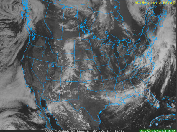
College of DuPage / National Oceanic and Atmospheric Administration
They maintain a great website for accessing satellite images and displaying the output (predictions) from numerical models. We’ll use both of these extensively in the three weeks to come: the numerical models when we are a long way out and the satellite images when we get closer to the big day.
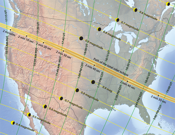
Because we are pretending here, this satellite image substitutes for the day before the eclipse. The time of this image is 18:15 Universal Time, which translates as 11:15 a.m. or 12:15 p.m. local daylight time in the western and central states and 1:15 or 2:15 p.m. in the eastern half of the continent. At this time of day, the Moon’s shadow would lie near Columbia, Missouri.
This is a visible-light image, so clouds are white and the rest is ground. We are mostly interested in where the cloudy areas today will move to tomorrow. Generally speaking, they will all lie east of where they are in this image — we’ll find out what the computer models think in a moment.
The speckled white clouds in the dark areas over Missouri, Illinois, and parts of Kentucky and Tennessee are cumulus clouds. They will evaporate about 45 minutes after the Moon first touches the Sun. Heated ground drives cumulus, and its energy supply is cut off as the Sun is covered and temperatures begin to fall.
The arcing band of cloud across the Gulf States, Georgia, and coastal South Carolina is a cold front with embedded thunderstorms. It should be moving offshore in the next 24 hours. Presumably, it will be replaced by the cumulus cloud now over Tennessee, but South Carolina has lots of tropical moisture and the small cumulus clouds may turn into thunderstorms tomorrow, especially as the eclipse comes in the mid-to-late afternoon, when heating is near its maximum.
Finally, the extensive cloudiness over the Front Range of the Rocky Mountains, from New Mexico to Montana, is a big problem. That cloud is a mixture of several cloud layers, including more than a few thunderstorms, and it’s caused by a flow of moisture coming north from the Gulf of Mexico. Most of the problems it will bring to the eclipse track are in eastern Wyoming around Casper. To complete our picture, there is a small cluster of convective buildups in eastern Nebraska, and scattered clouds over the mountains of western Wyoming.
So, where is it all going to be tomorrow?
How to Read a Weather Model
There are several models available to us that give cloud predictions, and I’ll pick one we call the NAM (which stands for North American Mesoscale). The 24-hour forecast from the NAM is shown below. Right away, we see a couple of new problems.
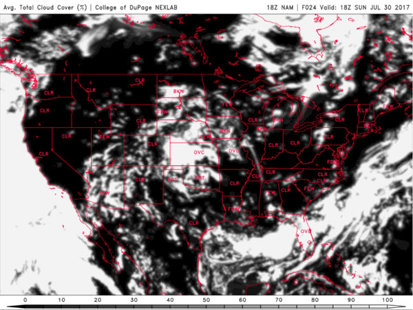
College of DuPage / National Weather Service
First, notice that the fog offshore from Oregon has now moved up against the coast, and there is a small “tag” of cloudiness inland, just west of the CLR (“clear”) text. This is fog and low cloud that has moved down the Columbia River past Portland and spread into the Willamette Valley. It’s dissipating, but it was forecast to be a little thicker at eclipse time, about 45 minutes before this forecast time. If you’re going to Salem, Oregon, and this shows up on the model the day before, head across the Cascade Mountains toward Madras to see the eclipse.
In the east, the cold front has moved offshore, just as we hoped, and South Carolina is looking good. There may be some cumulus clouds, but the model shows little of significance, except for a bit of cloud over the heights of the Appalachians near the Tennessee border.
The Great Plains are a big problem. There’s extensive broken cloud over eastern Nebraska and into Missouri, but there is also a fairly large opening toward the Wyoming border. It’s a bit of a chance to put your faith in that opening, but at least the model says that heading west is a better choice than heading east. In later posts I’ll discuss how to evaluate these forecasts for reliability. I plan to be in Jackson, Wyoming, and this model, coupled with the satellite image, would make me feel pretty good about tomorrow.
However, remember that this is a computer model, and for sure some parts of it won’t work out. In later posts I’ll have something to say about covering your bets.
| Jay Anderson's eclipse-weather website now offers a “quick-stop weather” page that links directly to satellite images, models, highway traffic cameras, forest-fire smoke reports, and a few other things. It’s image-free for quick loading on eclipse day. Go to eclipsophile.com/real-time-weather. |
For more eclipse resources, visit our Total Solar Eclipse 2017 page or check out our FREE eBook on eclipse photography!
About Jay Anderson
Jay Anderson has been looking at eclipses and eclipse climatology for nearly 30 years, helping to make the shadow experience more rewarding (and more certain) for those inclined to stand within the umbra. See more of his climatology and weather for celestial events at eclipsophile.com.


Comments
Tom-Laskowski
July 31, 2017 at 7:00 pm
Great article and advice. I'll be the first to say this since I think many others are thinking the same thing. I hope you will have an Eclipse Eve forecast posted here for those of us who are going to be mobile and looking for a good chance location. Anyone who has seen 30 eclipses certainly knows the weather. Thanks!
You must be logged in to post a comment.
Ernie Ostuno
August 4, 2017 at 2:39 am
One thing that could really gum up the works from Missouri to South Carolina is if a tropical cyclone comes out of the Gulf of Mexico. This is the time of year when the African easterly wave train gets more active and the long range models are indeed showing that happening in the next 10 days.
You must be logged in to post a comment.
duanem
August 4, 2017 at 2:48 am
I saw this hurricane to emerge on my weather app (Flowx) this morning. And it's predicted by both the NOAA and Environment Canada model. But I didn't want to prematurely alarm anyone, it's still early days. And if it does eventuate, it hits Florida 7 days prior to the eclipse.
You must be logged in to post a comment.
duanem
August 4, 2017 at 2:42 am
Hi Jay,
I've just added the solar eclipse path and shadow data (Fred Espenak's data) to my Android weather app called Flowx. This can be overlaid with the NOAA GFS or Environment Canada GDPS data, particularly the cloud data. Unfortunately, I don't have the NAM data in the app yet, it's on my list of to-do's.
I think this is the first app to do this and I'm trying to let people know about it but it's hard to be heard above the excitement.
I have a YouTube of the feature here: https://www.youtube.com/watch?v=qtqeE-O0Tfk
Feel free to email me, I'd be happy to hear feedback and make improvements. I actually got the high resolution data of the shadow but worried about the download size and wasn't sure if it added much more benefit to an ellipse shape.
Cheers, Duane.
You must be logged in to post a comment.
You must be logged in to post a comment.