 0
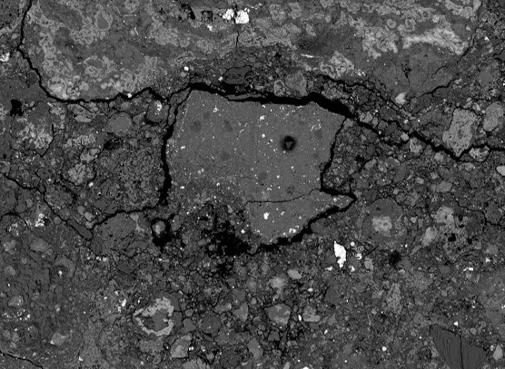
0A new catalog pinpoints volcanic cones in the best available surface images of Venus – those gathered 30 years ago by NASA’s Magellan spacecraft.
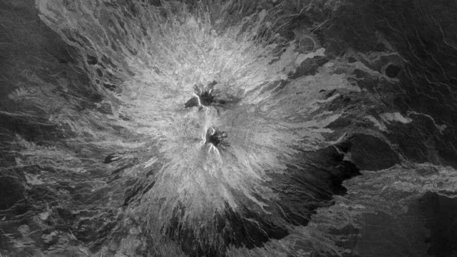
NASA / JPL
Everybody has a different memory of what they did during the long days of pandemic lockdown. While some of us struggled to stay afloat among work and childcare, others — like graduate student Rebecca Hahn (Washington University in St. Louis) found the quiet time they needed for time-consuming endeavors.
Hahn took the highest-resolution imagery available of the Venusian surface — that gathered by NASA’s Magellan spacecraft 30 years ago — loaded it into mapping software like that used by engineers and urban planners on Earth. Then she set out to map every single volcano visible in the grainy, black-and-white images by hand.
“We knew there were these maps or catalogs made before, but no one had really taken the time, probably because nobody had the time, to go to the level of detail that Rebecca did,” says Hahn’s thesis advisor, Paul Byrne (Washington University in St. Louis). Hahn and Byrne describe the work in JGR Planets.
The result is the most detailed and complete map of volcanoes on the surface of Venus ever made, probably surpassing that of any other planet — including Earth. The new catalog lists the size and location of 85,000 individual volcanoes, 50 times more than the most complete previous catalog. The effort took Hahn more than two years.
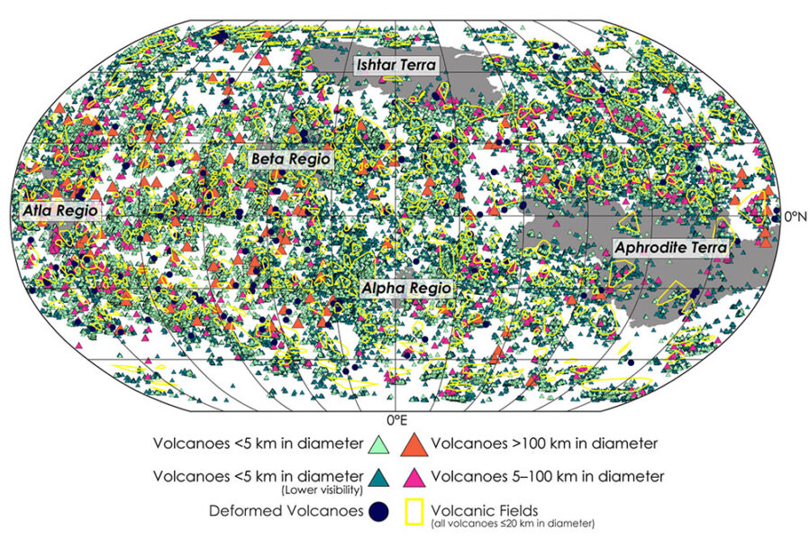
Map created by Rebecca Hahn (Washington University in St. Louis)
“The complete data set, with locations of all volcanoes and planforms of the larger volcanoes, will be immensely useful both for mission planning and for future research on Venus volcanism and its relationship to interior processes,” says Robert Herrick (University of Alaska Fairbanks). Herrick recently found the first clear sign of active volcanism within the same set of Magellan images, but he wasn’t involved with the present study.
A Titanic, Tedious Endeavor
Magellan mapped about 90% of Venus’s surface using radar, so these images aren’t really pictures, Hahn explains. Magellan beamed radio signals toward the surface of Venus as it flew by in an elliptical orbit, meaning that the angle and distance of the spacecraft in relation to the planet wasn’t always the same. Surfaces with varying inclinations and material properties reflected those waves back toward the spacecraft, which detected the returning radar and converted it into imagery. This makes Magellan’s images extremely challenging for automated analyses, such as image recognition software, to process. Humans are still better at making out shapes and patterns from messy images.
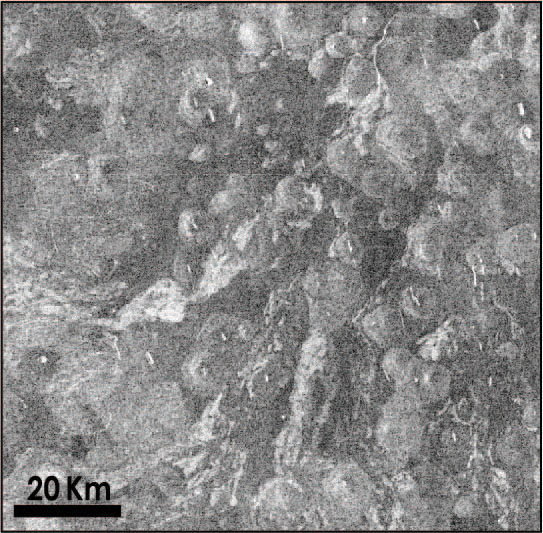
Magellan’s low resolution also made the task challenging. A 1-kilometer feature on the surface appears as 7 pixels in an image, so it’s difficult to make out structures of that size. Volcanoes less than 5 kilometers (3 miles) in diameter make up about 99% of the volcanoes in the map, but there are probably many more too small to account for. “We have kilometer-size volcanoes on Earth and many that are smaller than that, so surely there are many small volcanoes on Venus that we just missed,” Hahn says.
Mysteries of Venusian Volcanism
This kind of catalog helps scientist understand why volcanism is concentrated or absent from certain areas, and how this correlates to things like the thickness of the lithosphere or other surface features, Byrne explains.
JGR Planets
Already researchers are realizing that Venusian volcanoes are likely to be either less than 20 kilometers in diameter or more than 100 kilometers across, with few in-between in size. Large volcanoes also seem to be clustered toward the equator, with none of them at the south pole and relatively few near the north pole.
What the researchers haven’t found yet is any obvious global-scale trends. “On Earth there are global trends because we have plate tectonics, but Venus doesn’t appear to have a globally connected network of plates,” Byrn says. “Instead of volcanoes clustered into long chains, they seem to be all over the place.”
Hahn and Byrne have made their map publicly available for other researchers to use. “I have already spoken to a couple people that were using my data, and it’s just exciting,” Hahn says. Additionally, three new Venus missions from NASA and the European Space Agency are scheduled to fly over the next decade, and this information could help researchers pinpoint interesting areas for future high-resolution observations.
About Javier Barbuzano
Javier Barbuzano is a bilingual Spanish-English science writer and communicator. He graduated from Boston University with a master’s degree in Science Journalism. He writes about many topics, but astronomy and technology are his favorites.

Comments
You must be logged in to post a comment.