 1
1Scientists have used an innovative measure of Mars's gravity to reveal the origin of the mountain the Curiosity rover is exploring.
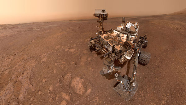
NASA’s Curiosity rover has been exploring Mars ever since it first landed inside Gale Crater in 2012, and it’s been making discoveries of ancient lakebeds and organic molecules ever since. Yet scientists still debate the origin of the very terrain that Curiosity is studying.
NASA / JPL / MSSS
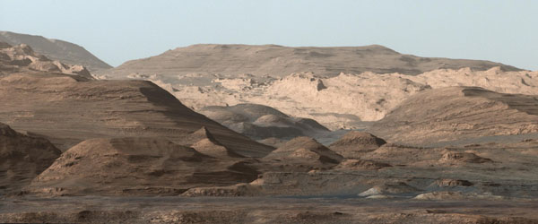
The debate centers on the formation of the central peak of Aeolis Mons (informally known as Mount Sharp), which Curiosity is currently climbing. The mountain is higher than the rim of Gale Crater, which suggests it’s not just a peak created during impact. Some scientists have proposed that sediments blew in long after the ancient lakes and rivers had dried up, filling Gale Crater to its 3-mile-high brim. Only recently, geologically speaking, did wind blast it away to reveal the mountain at the center.
Now, a new study appearing in the February 1st Science makes innovative use of Curiosity’s navigation system to do science the rover was never intended to do — and prove that theory wrong.
A Smart Way to Measure Gravity
To understand the mountain’s origin, Kevin Lewis (Johns Hopkins University) and his colleagues needed to study the rock that’s out of sight beneath the rover’s wheels. Curiosity doesn’t carry so-called gravimetric instruments, which would allow it to study the gravitational pull of the rock beneath it and hence probe its density. So Lewis’s team made do: They utilized the onboard navigation system for science.
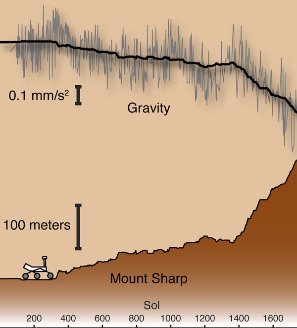
Have you ever wondered how your smartphone or tablet knows where it’s pointing, or how your laptop knows to turn off when you’re carrying it? These devices carry accelerometers, instruments that tell the devices where they are and where they’re going. Curiosity has the same kind of sensor as part of its navigation system, called the Rover Inertial Measurement Unit. Using the RIMU the team tracked Curiosity’s orientation over the course of almost five years as the rover traversed 11 miles (18 kilometers) along the plains of Gale Crater and up the lowermost slopes of Mount Sharp. The path included a vertical climb of 1,150 feet (350 meters), as Curiosity left the crater plains and began ascending Mount Sharp in 2014.
Kevin Lewis
If you were to lift Curiosity up into the air by 1,150 feet, it would feel a certain amount of gravitational pull back toward the center of Mars. But since there’s ground, not air, beneath Curiosity’s wheels, it feels a stronger pull as it climbs. Lewis and his colleagues measured this small change in gravity to calculate the density of the rock doing the pulling. To their surprise, the gravity of Mount Sharp was less than expected — which means its rock layers appear to be unexpectedly light.
“[The rock] turns out to be a lot less dense than sedimentary rocks on Earth — like, a lot less dense,” says Ray Arvidson (Washington University in St. Louis), who is on the Curiosity science team but was not involved in the study. “That's pretty well unheard of for sedimentary rocks on Earth that get deeply buried.”
That’s because if miles-high layers of sediment had once filled Gale Crater, their cumulative weight would have squeezed out any air spaces in the rock beneath it, the same way that a heavy tractor compacts the soil beneath its treads. Since the rock beneath Curiosity seems to be really porous, that means there can’t ever have been much material on top of it.
Instead, Lewis calculates that sediments could only have filled Gale Crater less than halfway up. That means a different origin for Mount Sharp: rather than a recently wind-blasted sand pile, deposits could have built it up more gradually.
Making Mount Sharp
A picture where deposits built Mount Sharp looks like this: Back in the day, abundant rain and snow would have carried sand and gravel down from the crater’s rim. Later, shallow lakes would have topped those layers off with sulfate-rich mud. Then, after Mars dried up, wind slowly eroded these layers away. On top of these multi-layered deposits, winds brought in sand, dust, and volcanic ash, shaping Mount Sharp into its current form.
“Our overall interpretation of this kind of geologic strip chart recorder as you move from the bottom to the top of Mount Sharp, it's still pretty much valid,” Arvidson notes. But, he adds, the origin of the peak affects the details of how scientists interpret Curiosity’s finds, such as the types of minerals they expect and the particulars of ancient water circulation.
NASA / JPL-Caltech
Curiosity just left its perch on Vera Rubin Ridge for a lower, clay-rich region of Mount Sharp. But further in the future, the rover has its sights set on higher elevations. The sulfate-rich layers, presumably deposited when shallow lakes filled the crater, are 6,500 feet away. And 2,600 feet beyond that is a sudden transition to what might be windblown deposits. But whether the rover makes it all the way to these interesting sights remains to be seen as scientists plan the third extension to the mission.
“It depends on how exciting the rocks are on the way,” Arvidson says, “and how much we traverse as opposed to stop and smell the flowers.”
About Monica Young
Monica Young, a professional astronomer by training, is News Editor of Sky & Telescope.

Comments
fif52
February 3, 2019 at 7:08 pm
amazing as Curiosity got stuck twice in powder dunes. Aeolis Mons (centre of image). How old do they date it. isn't it inside Gale Crater? would be nice to return with a sample.
You must be logged in to post a comment.
You must be logged in to post a comment.