 0
0Careful study of data from the New Horizons mission indicates that an iconic, caldera-looking feature isn’t what it seems.
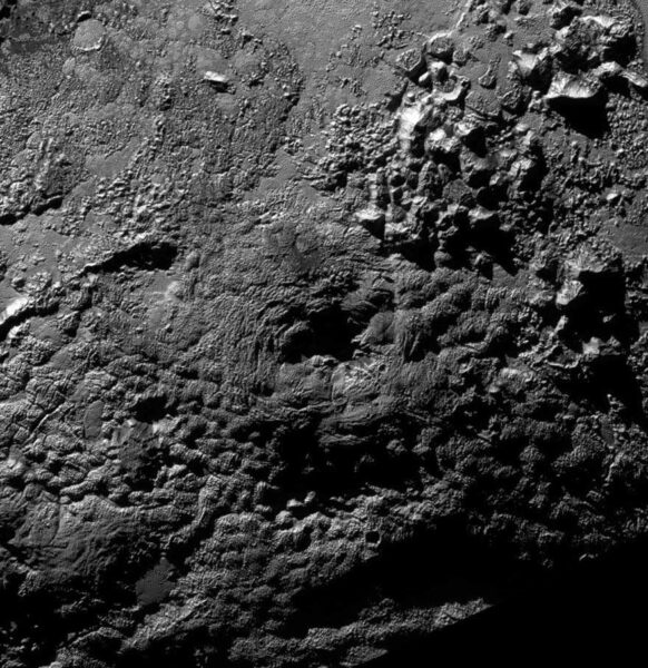
When the New Horizons spacecraft flew by Pluto in July 2015, it stunned us with a landscape of ice mountains, glaciers, and strange geologic features. One of these mysterious features was Wright Mons and its companion, Piccard Mons. Located along the southern hemisphere’s day-night boundary when New Horizons sped by, these two features rise a few kilometers high but are immensely broad, each spanning well over 100 km.
NASA / JHU-APL / SWRI
Seen in stark relief, Wright’s central pit looks like a gaping hole plunging into the dwarf planet’s heart. Piccard lies in evening shadow; we only see hints of it thanks to sunlight scattered by Pluto’s hazy atmosphere, but it does seem to have a central depression, too. Initially, mission scientists thought Wright and Piccard might be cryovolcanoes, spouts that spew lava made of sludge-like water ice. (Out here at the edge of the solar system, water ice is so hard that it serves as rock.)
But appearances can be deceiving.
Instead of being the collapsed summits of ice volcanoes, Wright and Piccard’s holes may just be places not overrun by vast outpourings of icy goo from vents in the landscape, Kelsi Singer (Southwest Research Institute) suggested October 4th at the annual Division for Planetary Sciences meeting.
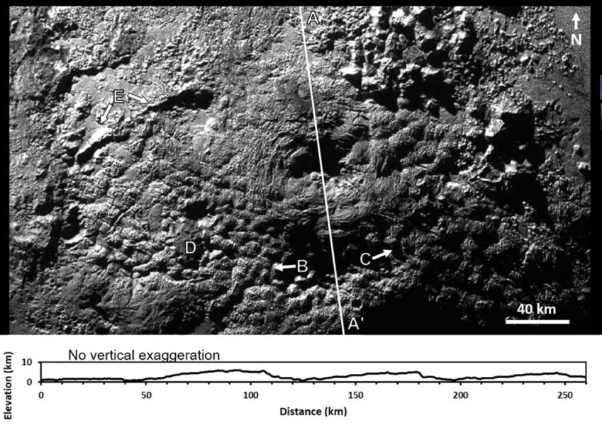
Singer and her colleagues used New Horizons’ data to take a closer look at the terrain around Wright. It’s a landscape of broad swells, with undulations roughly 10 km wide overlain by nubbly patterns that themselves are about a kilometer in scale. We’ve seen nothing quite like it in the solar system.
What’s intriguing about this wonderland is how the elevation changes — or, rather, doesn’t. Draw a chord from north to south across Wright Mons and plot the elevations along the line, and here’s what you’ll see:
Modified from Kelsi Singer et al.
No surging slopes or bottomless pits to be had, and the floor of Wright’s maw is about level with the surrounding surface. That suggests that what looks like a ring-shaped massif is instead part of a gradual, irregular pileup of cryolava that — for whatever reason — didn’t fill in this part of the terrain.
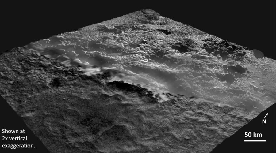
Wright looks so dramatic because sunlight hits it at a steep angle in New Horizons’ images. But adjust the contrast in the image or check the topographic map, and it becomes clear that the mount’s interior is as hummock-ridden as the exterior, Singer says. If we look at a projection with a more accurate perspective, the depression is less striking:
NASA / JHU-APL / SWRI / Kelsi Singer / Paul Schenk
Singer herself long thought Wright was a caldera, but she couldn’t find the evidence. “I felt like I was barking up the wrong tree for several years,” she says. “When I stopped trying to make the middle of Wright and Piccard the middle of anything, then things were still mysterious but weren't nearly as hard to explain.”
Instead, she thinks that icy lava oozed up from below through unidentified openings. There are signs of older, fractured terrain peeking out from underneath the material, but there’s no clear direction to the flow — and definitely no signs that it flowed out of Wright. (Piccard’s too fuzzy to see properly.)
At Pluto’s surface temperature of about 40 kelvin (−390°F), water ice would quickly freeze on the surface — even with things like ammonia keeping it from becoming rock-hard — so the ooze could have formed a hard carapace as it traveled.
The near-total absence of craters suggests this terrain might be only 1 billion years old. But that raises a question: What’s the heat source that would melt Pluto’s water-ice rock to become molten? Planetary scientists face the same problem in explaining the vast, active glacier Sputnik Planitia (the left lobe of Pluto’s “heart”). The dwarf planet should have cooled off long ago, and because it and its largest moon, Charon, always point the same face at each other, there’s no tidal pull to knead the world’s interior.
“There is still a lot to be figured out about how this kind of effusion onto the surface could work at all,” Singer says. “But we see these crazy resurfaced terrains that don't look like they are just from erosion, and we see what might be evidence for multiple events. So some kind of movement of material onto the surface still seems like the best way to make these terrains.”
The study is currently under review for publication and will hopefully come out in a few months.
References:
K. Singer et al. “Exploring morphometry, composition, and cryovolcanic emplacement mechanisms for the Wright Mons Region on Pluto.” Abstract 114.02. DPS 2021 meeting.
O. L. White et al. “The Geology of Pluto.” The Pluto System After New Horizons, eds. S. A. Stern et al. University of Arizona Press 2021.
About Camille M. Carlisle
Science Editor Camille M. Carlisle handles science features for Sky & Telescope. She specializes in black holes, Mars, and whatever she happens to be writing about at the time. Frolic with her through the delights of black holes in her blog, The Black Hole Files.


Comments
You must be logged in to post a comment.