 0
0Polygons buried beneath the surface of Mars indicate an abrupt transition in the planet’s early history.

Polygonal patterns showing evidence of changing environments on Mars go well below the wet-dry cycles that led to mud-crack patterns previously observed on its surface. Ground-penetrating radar on China’s Zhurong rover has revealed large, wedge-like structures tens of meters below ground level, suggesting other changes on ancient Mars.
Previously, missions have observed mud cracks on the Martian surface. Mud cracks are also commonly seen on Earth, where dry surfaces absorb precipitation and turn to mud. When the water evaporates, the mud shrinks and cracks open on the surface. Repeated wet-dry cycles sculpt the cracks into polygonal shapes.
Early Martian landers spotted such surface cracks, and recently, NASA's Curiosity rover recorded arrays of centimeter-scale hexagonal mud cracks that indicate extended seasonal fluctuations during Mars’s warmer and wetter youth.
However, Jinhai Zhang (Chinese Academy of Sciences) and colleagues have now found evidence of much larger polygons buried below the surface, reporting their discovery in Nature Astronomy. These structures formed via a different mechanism.
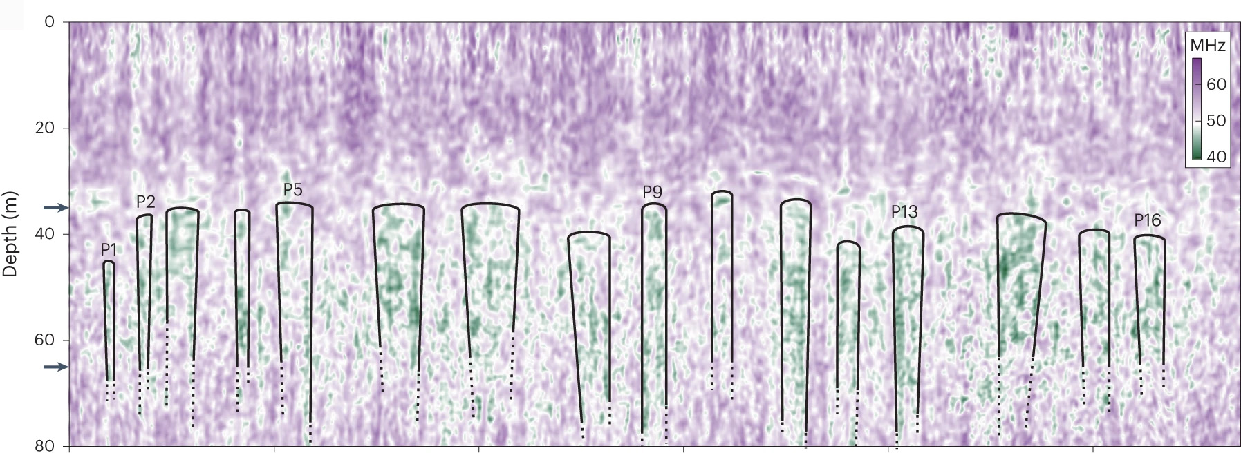
Analysis of data from the ground-penetrating radar on Zhurong has revealed polygonal structures more than 35 meters (115 feet) below the surface. The cracks between polygons are themselves quite wide (27 meters, or 88 feet), almost half again the polygons’ average width of 67 meters. The difference in crack-to-polygon ratio rules out their formation by wet-dry cycles, and instead indicates the presence of long-ago freeze-thaw cycles.
“They most likely formed by thermal contraction cracking," Zhang says. Water, soil or mixtures of the two filled in the cracks to form the wedges the team observes. The 35 meters covering those layers were deposited over the past 1.6 billion years by long-term weathering, impacts, and transient floods.
Benton Clark (Space Science Institute), a team member on the recent Curiosity study who was not involved in the work on Zhurong data, thinks searching deeper could yield even more information on the history of water on Mars. That information would help answer what he calls "the big questions of ‘When were the wet spells on Mars?’ and ‘How long did they last?’" Answering these questions is of practical importance, too, to support future human exploration and colonization of Mars.
Zhurong landed on May 14, 2021, in Utopia Planitia, a northern plains site selected to look for evidence for a suspected ancient ocean. Scientists considered the site to be one of the best places on Mars to find ground ice at low to mid latitudes.

Zhang et al. / Nature Astronomy 2023 / CC BY 4.0 DEED
In its year of operation, the rover traveled nearly 1.2 kilometers (0.7 mile) while studying the surface. Its instruments included a ground-penetrating radar, able to observe features down to 100 meters — much deeper than the 10-meter range of the radar on NASA's larger and still-operating Perseverance rover, which landed in February 2021 in Jezero Crater.

Zhang et al. / Nature Astronomy 2023 / CC BY 4.0 DEED
A team led by Lei Zhang (Chinese Academy of Sciences) mapped features at various depths along a slice of data. Walls of polygons, which appear more like wedges in the 2D slices, start at depths of 35 meters and continue down to 65 meters. They find 16 buried polygon wedges over 1.2 kilometers, or about 60% of the rover’s overall path.
Zhang et al. / Nature Astronomy 2023 / xCC BY 4.0 DEED
An important difference between the surface and subsurface polygons is their widths. The surface polygons observed by Curiosity are a few centimeters wide, formed in repeated wet-dry cycles. The larger subsurface polygons Zhang’s group found, on the other hand, were once polygonal terrain, which forms in a colder environment. As frozen water slowly sublimates, turning straight from ice to vapor, it leaves behind polygons tens of meters in size. Examples on Earth are found mainly in cold regions, while examples on Mars have been found at mid to high latitudes. These are the first found in lower Martian latitudes.
Formation of the buried polygonal terrain “requires a cold environment and might be related to water/ice freeze-thaw processes” on early Mars, writes Zhang’s group. The researchers say the large polygons they found demonstrates that water froze at low latitudes. For water to freeze near Mars’s current equator would have required wide climatic fluctuations; Zhang suggests the cause could have been early Mars having a greater tilt of the axis on which it spun.

Zhang et al. / Nature Astronomy 2023 / CC BY 4.0 DEED
Whatever the cause, Zhang’s team concludes that the absence of buried polygonal terrain above the 35-meter level marks a “stark environmental transition” between 3.5 and 2 billion years ago, which may have marked the end of Mars’s wet period. Zhang adds that their paper "gives potential evidence that Mars used to be habitable from the perspectives of water and temperature."
“It’s very interesting they can see something like that with radar,” says Clark. “There may be a lot more [ice-related features] around, but we haven't come on places where it was exposed.” It could be a key to understanding the extent of Martian water resources available for potential colonists.
About Jeff Hecht
Jeff Hecht writes about science and technology, with a particular interest in all things optical. He first discovered Sky & Telescope when he was 10, and he still has the one-inch Wollensak refractor his father gave him then.


Comments
You must be logged in to post a comment.